Okotanpe-yama · Routes
↘ Okotanpe-yama — Summit Ridge
This route carries serious backcountry hazards. Its slope and ATES labels are planning estimates; they do not decide whether it is safe today or suitable for your group.
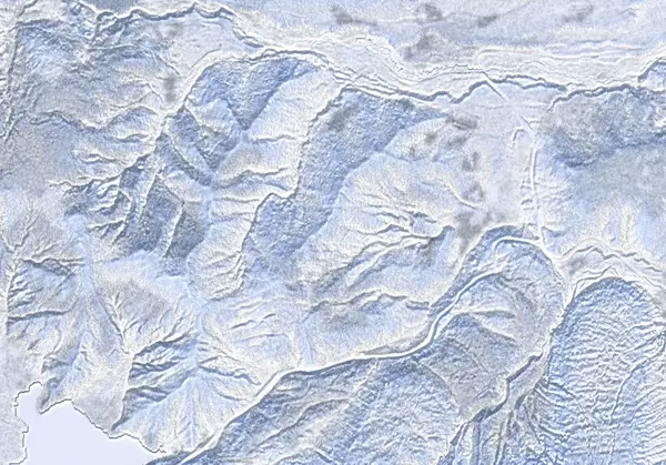 出典:国土地理院(標高タイル dem5a + DEM10B を加工して作成)
Steepness · profile
← Distance 4.9 km →
Per-segment terrain (data table)
| % | m | Steepness | Aspect |
|---|---|---|---|
| 0% | 523 | 13° | E |
| 3% | 530 | 22° | E |
| 6% | 542 | 35° | N |
| 10% | 592 | 40° | NE |
| 13% | 672 | 36° | NE |
| 16% | 727 | 36° | E |
| 19% | 751 | 38° | NE |
| 23% | 785 | 39° | NW |
| 26% | 789 | 36° | E |
| 29% | 826 | 40° | NE |
| 32% | 875 | 38° | E |
| 35% | 878 | 33° | W |
| 39% | 855 | 32° | NW |
| 42% | 896 | 39° | E |
| 45% | 947 | 39° | E |
| 48% | 970 | 39° | E |
| 52% | 960 | 39° | SE |
| 55% | 909 | 32° | NE |
| 58% | 857 | 34° | NE |
| 61% | 876 | 32° | S |
| 65% | 874 | 41° | SE |
| 68% | 835 | 38° | E |
| 71% | 799 | 36° | SE |
| 74% | 780 | 40° | SE |
| 77% | 781 | 36° | NW |
| 81% | 745 | 36° | SE |
| 84% | 730 | 36° | E |
| 87% | 679 | 39° | E |
| 90% | 636 | 38° | E |
| 94% | 594 | 34° | E |
| 97% | 545 | 27° | NE |
| 100% | 535 | 15° | N |
Route guide
The Summit Ridge climbs Okotanpe-yama (968 m) as a loop up a forested ridge from near Lake Okotanpe on the Shikotsu caldera rim. Hokkaido Wilds gives ~5 km, ~448 m of ascent, and a difficulty of 4.5/10 — short on both distance and vertical, but the source is explicit that it is 'intermediate despite the beginner classifications,' and the bake agrees: the descent aspect reads east (the source calls it northeast), a line median of ~33°, a maximum of ~42°, and an ATES rating of 'complex' with a release area near 27%. Of the three Shikotsu peaks (Izari, Ichankoppe, Okotanpe), this is the steepest and carries the highest fraction of avalanche terrain. Read this as a description, not a recommendation.
[Terrain] From the trailhead (42.818°N, 141.287°E, ~520 m), work around above Lake Okotanpe and climb an east-facing forest (41% open · 28% sparse · 31% dense) up the ridge to the summit. The bake's slope distribution centres on 33° with a 42° maximum — a steep zigzag on the way up, tree-dodging on the way down. The east aspect takes morning sun, and the ridgeline can pick up wind slab off the northwest flow.
[The main hazard is complex terrain with broad start zones] ATES complex with a ~27% release fraction is a distinct amount of avalanche terrain for a tour this short — the highest of the three Shikotsu peaks. The small vertical and beginner grade invite complacency, but a 33°-median forest ridge can produce slabs and point releases alike. The east aspect can destabilise the near-surface under morning sun, and the mix of dense trees and steep pitches makes whiteout navigation awkward. No dedicated avalanche bulletin covers the Shikotsu area — check the Japan Avalanche Network before departing and make your own stability assessment. Okotanpe-yama is not an active volcano, so no volcano bulletin applies.
Access & logistics
Start & parking: A trailhead near Lake Okotanpe (42.818°N, 141.287°E, ~520 m). The prefectural road to Lake Okotanpe closes in winter, so confirm plowing and approach in advance.
Getting there: A car is the practical option — from the Sapporo side toward Lake Shikotsu / Lake Okotanpe. Expect snow and ice in winter — 4WD with winter tyres.
The day: ~5 km, ~448 m of ascent — a short half-day. Climb the east forest ridge to the summit and descend the ascent line; allow time for the steep pitches and dense trees.
Gear: Carry full avalanche gear and reliable navigation; on an east aspect, mind the timing of the morning sun.
Info: No dedicated avalanche bulletin covers the Shikotsu area — check the Japan Avalanche Network before departing.
Today / tomorrow briefing
Loading…
Set reminders inside Google Calendar
Hokkaido Wilds · Rob Thomson — HokkaidoWilds.org · CC BY-SA 4.0
A planning aid, not a verdict. Always check the day’s official avalanche bulletin and decide in the field.
Route data source: Rob Thomson — HokkaidoWilds.org · CC BY-SA 4.0 · ↓ Download GPX